Property Surveys When Buying a Home in Canada
A document-and-field method for deciding whether an existing plan is useful, matching it to title and visible improvements, identifying gaps, and commissioning the right survey work before a transaction becomes firm.
Property Surveys When Buying a Home in Canada: Read Boundaries, Improvements, and Rights
A property survey connects a legal parcel with measured features on the ground. Depending on province, purpose, and age, the document may show boundaries, dimensions, buildings, fences, easements, rights-of-way, encroachments, and survey monuments.
It does not automatically prove zoning compliance, building permits, structural condition, ownership of every fence, current site conditions, or a right to use land outside the parcel. An old plan can be valuable evidence while still missing a newer deck, addition, shed, pool, severance, road widening, or neighbour structure.
For a buyer, the useful question is not “Is there a survey?” It is “Which document is this, what did the surveyor certify, on what date, how does it match current title and the site, and which decision remains unresolved?”
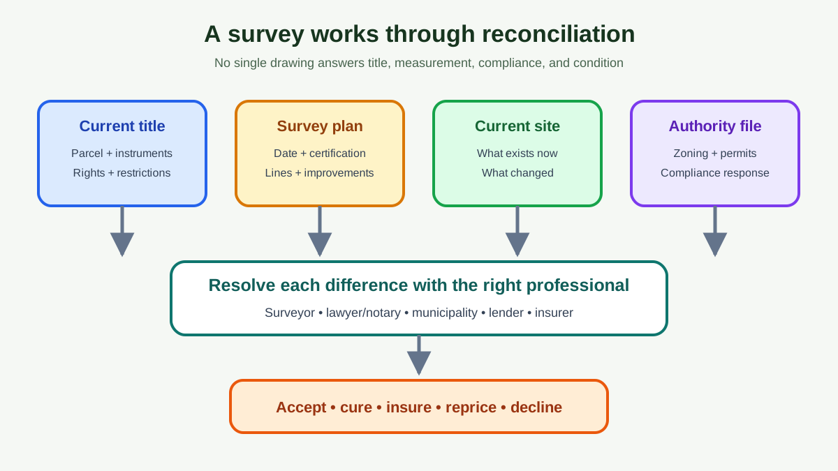
Short answer: use a four-document reconciliation
Compare these together:
- Current title and registered instruments: legal owner, parcel description, charges, easements, rights, covenants, and plans.
- Survey document: parcel, certification, date, field evidence, dimensions, improvements, annotations, and limitations.
- Current physical site: buildings, fences, drives, walls, utilities, shorelines, access, and recent work.
- Municipal/authority record: zoning, setbacks, permits, approvals, road or utility interests, and compliance response.
Then ask a licensed land surveyor and real-estate lawyer or notary to resolve differences within their scopes. A home inspector is not a boundary professional, and a title search does not measure where the garage sits.
Survey systems are jurisdiction-specific
Most residential parcels fall under provincial land and survey systems. Natural Resources Canada's Canada Lands survey overview explains that its federal system covers Canada Lands such as territories, reserves, national parks, and offshore areas; it does not manage provincial or municipal surveys or property rights.
The name and typical transaction document vary. Alberta commonly uses a Real Property Report. British Columbia transactions may refer to a survey certificate. Ontario may have a plan of survey or reference plan, among other registered and private survey products.
Quebec uses its cadastral and location-certificate practices. Other provinces have their own statutes and professional standards.
Do not apply an Alberta compliance-stamp expectation to an Ontario purchase or assume a BC survey certificate serves every purpose in Quebec. Ask the local lawyer and licensed surveyor which product answers the transaction question.
Identify the document in front of you
Record:
- title or product name;
- surveyor and firm;
- professional signature, seal, or digital certification;
- client and intended purpose, if stated;
- fieldwork and plan dates;
- legal description, parcel identifier, civic address, and title number;
- scale, north arrow, legend, units, datum, and plan number;
- certification wording;
- exclusions, notes, copyright, and reliance limits;
- municipal review or compliance evidence, if any.
A real-estate listing sketch, tax map, geographic-information-system screenshot, architectural site plan, fence quote, subdivision marketing plan, and surveyor's plan are not interchangeable.
The Alberta Land Surveyors' Association defines a Real Property Report as a legal document prepared by an Alberta Land Surveyor showing property boundaries and visible improvements relative to them. It says an RPR includes the legal description, title number, visible improvements, structures crossing into neighbouring or public land, and registered easements and rights-of-way.
Match the survey to the current title
The survey and title should describe the same parcel. Check:
- lot, block, plan, concession, range, section, parcel, or metes-and-bounds description;
- property identifier or title number;
- municipal address, recognizing it is not the legal description;
- severances, consolidations, road widenings, expropriations, or boundary adjustments after the plan date;
- benefiting and burdening easements;
- registered plans referenced by instruments;
- parking, access, waterfront, or shared-service parcels;
- condominium/strata lot versus common property.
If the survey predates a severance or the legal description differs by one part, do not mark it “close enough.” Give both documents to the surveyor and lawyer.
British Columbia's regulator notes in its LTSA information guide that a title search is often the first due-diligence step and that registered interests can affect the land. It also cautions that boundary-description errors are among statutory exceptions in BC's title system.
Read lines, symbols, and dimensions cautiously
Locate the legend before interpreting:
- surveyed boundary line;
- fence, wall, hedge, or occupation line;
- building foundation, eaves, steps, deck, shed, garage, pool, or retaining wall;
- survey monument found, planted, restored, or calculated;
- easement or right-of-way limit;
- setback or offset dimension;
- road, lane, reserve, water boundary, or utility feature;
- bearing and distance;
- encroachment note;
- area and scale.
A fence line is evidence of occupation, not automatic proof of the legal boundary. The Association of Ontario Land Surveyors' boundary tips warn that a previous fence may not accurately represent the property boundary and recommend retaining an Ontario Land Surveyor to locate it.
Do not scale a PDF with a ruler to decide whether a garage clears a line. Use certified dimensions or ask the surveyor.
Compare every visible improvement with the plan
Walk the exterior with the plan and create an exception list:
| Site feature | Shown? | Same footprint? | Near boundary/right? | Follow-up |
|---|---|---|---|---|
| Main building | ||||
| Addition | ||||
| Garage/carport | ||||
| Deck/porch/steps | ||||
| Shed/accessory building | ||||
| Fence/gate | ||||
| Retaining wall | ||||
| Pool/hot tub | ||||
| Driveway/parking pad | ||||
| Well/septic components | ||||
| Dock/shore work |
Photograph material differences and date the walk. A 1998 plan does not show the 2015 deck merely because the seller staples a permit to it.
If a deck, porch, balcony, stair, or hot-tub platform is missing from the plan, use the deck and balcony buyer inspection map to assess its load path, water path, records, safety, and repair scope while the surveyor and lawyer resolve location and rights.
For pools and spas, continue with the pool and hot-tub due-diligence guide to match vessel, enclosure, equipment, drains, deck, permits, and utilities to the site evidence. For significant trees, use the arborist inspection map while the surveyor and lawyer resolve trunks, boundaries, easements, and ownership.
“The survey never expires” can mislead a buyer
ALSA says an RPR technically does not expire but becomes outdated when improvements such as a fence, deck, or garage are added or changed. That distinction is useful across Canada: a document can remain an authentic record of what was surveyed on its date while being inadequate for today's transaction.
Test staleness through events, not age alone:
- improvements built, removed, expanded, or relocated;
- fence or retaining wall replacement;
- neighbour construction near the line;
- parcel creation or boundary adjustment;
- new easement, utility, road, or municipal acquisition;
- natural water-boundary movement;
- fire or demolition;
- title description change;
- survey monuments disturbed;
- current lender, insurer, lawyer, or authority requires more.
A five-year-old plan may be useful if nothing changed. A six-month-old plan can be incomplete after a new fence.
Survey, municipal compliance, and permits answer different questions
A surveyor measures and reports under the applicable professional standards. A municipality decides zoning, setback, and permit issues under its authority. A lawyer advises on title and contract. None should be silently substituted for the others.
An Alberta RPR can be submitted for a municipal compliance review, but the resulting municipal response and its qualifications must be read. In other provinces, a municipality may provide zoning or permit information through a different process.
Ask:
- Does the authority confirm compliance, identify non-compliance, or state that it did not review certain features?
- Was the current improvement shown and assessed?
- Is there a permit and final inspection?
- Does a variance, agreement, tolerance, or encroachment authorization exist?
- Does the approval run with land, expire, or depend on conditions?
- Does the lender accept the response?
A building can sit within the boundary and still violate a setback. A permit can exist for a structure that was built in a different location.
A survey is not title insurance
Survey evidence can reveal where improvements and rights sit. Title insurance provides contractual coverage for specified risks, exclusions, limits, and conditions. It does not move a fence, create missing legal access, approve a setback, or guarantee future construction rights.
The title-insurance audit separates legal coverage from physical, permit, and operational due diligence. If a known issue appears on a survey, disclose it to the lender, lawyer, and title insurer; do not assume an unknown-defect clause covers a disclosed condition.
Obtain the actual owner and lender policy forms and endorsements. A lender's coverage protects the lender's interest, not necessarily the buyer's loss.
Easements require the instrument, not a coloured strip alone
A survey may plot an easement area, but the registered instrument defines purpose, parties, rights, limits, obligations, and amendments. Obtain it through the lawyer or land registry.
For each easement, record:
- benefiting and burdened parcels or authorized body;
- registration number and date;
- mapped area;
- access, utility, drainage, support, construction, repair, or other purpose;
- vehicle, pedestrian, seasonal, or emergency scope;
- rights to excavate, remove vegetation, enter, install, repair, and restore;
- maintenance and cost allocation;
- interference restrictions;
- relocation, release, and consent rules.
Use the separate easement and right-of-way buyer audit when the right affects access, a building envelope, future work, or a shared service.
Encroachments need a measured response
An encroachment occurs when an improvement or use crosses a boundary or protected area without the right the buyer assumes. Common examples include a garage eave over a neighbour's parcel, a fence inside the lot, a driveway beyond an easement, or a shed in a utility right-of-way.
Do not estimate severity from appearance. Obtain dimensions, ownership, title instruments, agreements, permits, and legal advice.
Possible responses can include removal, relocation, registered agreement, easement, licence, boundary adjustment, municipal authorization, price adjustment, holdback, insurance endorsement, seller cure, or declining the purchase. Availability depends on jurisdiction, lender, neighbour, authority, time, and contract.
The encroachment decision guide shows how to classify the structure, direction, land owner, legal right, value effect, and cure.
Rural and waterfront parcels need a wider scope
Large, irregular, wooded, agricultural, island, and waterfront parcels can add:
- unsurveyed-looking occupation lines;
- private roads and bridges;
- shore road allowances;
- natural or ambulatory boundaries;
- accretion, erosion, or water-level questions;
- Crown or Indigenous interests;
- utility and pipeline corridors;
- well, septic, drainage, and shared-service areas;
- mineral, timber, grazing, or agricultural rights;
- conservation and environmental restrictions;
- subdivision expectations.
Natural Resources Canada says clear boundary systems support transfers, mortgages, subdivision, and land-use planning, but the relevant survey authority depends on whether the parcel is Canada Lands or provincial land.
Start with the rural property due-diligence map, then ask the local surveyor which fieldwork and plan product fit the intended use.
Condominiums and strata properties still have survey questions
The unit is defined by the registered condominium or strata plan and governing law, not by the drywall assumption in a listing. Parking, lockers, patios, yards, balconies, storage, and driveways may be separately titled, exclusive use, limited common property, common elements, leased, or assigned.
Have the lawyer reconcile:
- unit/strata lot plan and title;
- parking and locker description;
- exclusive-use schedules;
- alterations crossing boundaries or common property;
- easements and shared facilities;
- common-element responsibility;
- builder or owner changes from registered plan.
A tape-measured floor area is not a legal boundary opinion.
Decide whether to update, locate, or commission a new survey
Ask a licensed surveyor for a scoped recommendation. Options may include:
- review of an existing plan;
- field inspection and update, where professionally possible;
- boundary retracement and monument search;
- stakeout or fence-line location;
- new plan of survey or transaction product;
- reference, explanatory, easement, subdivision, or other registrable plan;
- elevation, topographic, construction, or site survey;
- expert opinion for a dispute.
State the intended decision: buying, lending, fence construction, addition, severance, boundary dispute, access, or municipal compliance. The cheapest product that answers another question is poor value.
ALSA notes there is no central database of Alberta RPRs and suggests contacting the surveyor who prepared an original report about an update. Local practices elsewhere differ; ask the regulator or surveyor directory where to start.
Request survey quotes that can be compared
Give each surveyor the same package and question:
- current title and legal description;
- every available survey or plan;
- property address and access contact;
- photographs of suspected changes;
- purchase, financing, fence, addition, or dispute purpose;
- features that must be located;
- required plan, report, field marks, or registration;
- lawyer, lender, authority, or insurer deadline;
- terrain, vegetation, water, access, and safety constraints;
- requested deliverables and reliance parties.
Compare scope before price. One quote may include title research, field monument search, buildings, fences, easements, plan preparation, and professional certification, while another covers only boundary stakes.
Ask about deposit, tax, travel, registry documents, monument restoration, extra field time, neighbouring access, rush work, revisions, digital and paper copies, and plan registration. Surveyors may be unable to promise a fixed completion date before reviewing evidence because missing or conflicting monuments can require more work.
Do not ask the surveyor to certify zoning or legal ownership outside the professional scope. State the decision clearly and let the surveyor recommend the product.
Control reliance and document rights
An old survey may have been prepared for a seller, lender, builder, or another transaction. Copyright, client duty, certification date, and third-party reliance can matter.
Ask the lawyer and surveyor:
- Is the copy complete and authentic?
- Can the buyer and lender rely on it?
- Does the original surveyor offer an update or letter?
- May it be reproduced in the transaction file?
- Does the plan contain a limited-use or client statement?
- Is professional liability attached to current work or only the original date?
Do not remove the title block, notes, signature, or scale when sending a plan. A cropped image can hide the legal description or limitation needed to interpret it.
Recheck the site before closing
A satisfactory survey review during conditions can become stale if the seller or neighbour changes the property before possession. At the final walkthrough, compare material exterior features again.
Look for a new or removed fence, shed, gate, retaining work, excavation, stockpiled soil, widened parking, damaged monument, utility trench, altered drainage, or blocked access. Photograph changes and contact the lawyer immediately rather than negotiating a private closing credit at the property.
The purchase agreement and local law determine remedies. The walkthrough is an observation step, not a new survey or a licence to delay closing unilaterally.
Put survey review inside the purchase agreement
Contract rights and deadlines are provincial and fact-specific. Ask the lawyer or real-estate professional for a condition that provides enough time to obtain and review title, registered instruments, survey evidence, current improvements, authority information, lender response, and insurance.
Define:
- documents the seller must provide;
- whether they must be current or updated;
- buyer's satisfaction standard;
- access for survey fieldwork;
- seller authority to share old plans;
- deadline and extension process;
- cure, holdback, price, or termination rights;
- permitted encumbrances on closing;
- representations repeated at closing.
BCFSA's current purchase-completion guidance says the buyer's lawyer or notary searches title for other legal rights, including registered easements and restrictive covenants. The survey review complements that search.
Do not receive the survey after financing and inspection conditions expire if the property has visible boundary or access risk.
A worked survey-gap example
A buyer receives a 2007 plan showing the house and detached garage. The current site also has a rear deck, shed, widened driveway, and replacement fence. Title shows a utility easement along the rear six metres.
The audit finds:
- deck and shed absent from plan;
- shed appears inside the utility strip;
- driveway crosses the side line visually but no measurement exists;
- fence is about 0.6 metres inside the apparent monument line;
- no deck permit or easement consent in seller records.
The buyer does not label all four features illegal. The surveyor measures relevant improvements; the lawyer obtains the easement; the municipality checks permit and setback records; the utility is asked about consent; lender and insurer receive the facts.
Only then can the buyer price removal, agreement, update, delay, or residual risk. The old plan was useful because it exposed what changed, but it could not resolve the changes alone.
Survey review checklist
Document identity
- Licensed surveyor and certification identified
- Product, client, purpose, and date understood
- Legal description and title match
- Legend, units, scale, north, and notes read
Site reconciliation
- Every building and exterior improvement compared
- Fences distinguished from boundaries
- Access and parking measured or documented
- Easement areas compared with use
- Neighbour improvements near lines reviewed
- Recent construction photographed
Decision closure
- Lawyer reviewed title and instruments
- Surveyor answered measurement questions
- Municipality/authority answered compliance questions
- Lender and insurer accepted disclosed issues
- Contract deadline remains open
- Cure, cost, timing, and residual risk recorded
What to do next
- Ask the seller for every survey, plan, RPR, certificate, municipal response, permit, and encroachment agreement.
- Order current title and registered instruments through the lawyer.
- Walk the property against the plan and photograph differences.
- Send a concise issue list to a licensed surveyor.
- Obtain authority, lender, and insurer responses within the condition period.
- Price any new fieldwork or cure with realistic timing.
- Amend, waive, or terminate only on legal advice and documented facts.
- Preserve the final survey and closing record for future work and resale.
Frequently asked questions
Do I need a property survey to buy a house in Canada?
Requirements depend on province, property, lender, lawyer, title insurer, contract, and known risk. Even where closing can proceed without a new survey, one may be valuable for boundaries, improvements, access, or planned construction.
How old can a property survey be?
There is no useful national age rule. Ask whether the parcel, title, improvements, neighbours, easements, roads, and intended use changed after the field date and whether the current reviewer accepts it.
Is a fence the property line?
Not necessarily. A fence can sit on, inside, or outside a legal boundary. A licensed land surveyor can locate the boundary under provincial law.
Does a survey prove a deck has a permit?
No. It can show location and dimensions within its scope. Permit, inspection, zoning, and compliance records come from the relevant authority.
Is an Alberta Real Property Report the same as a survey?
It is a specific legal survey document prepared by an Alberta Land Surveyor that shows boundaries and visible improvements relative to them. Other provinces use different products and processes.
Can title insurance replace a survey?
It may allow a lender or buyer to address specified title risks, but coverage does not locate a boundary, approve an improvement, create access, or answer every known issue. Review both the evidence and policy.
Who pays for a new survey when selling a home?
That depends on the purchase agreement, local custom, lender needs, seller representations, and negotiation. Define the required document, owner, deadline, and consequence in writing.
Can I rely on the seller's old survey?
Use it as dated evidence after verifying authenticity, parcel identity, changes, reliance terms, and current acceptance. Commission an update or new work when it cannot answer the buyer's decision.
This article is educational and does not provide legal, surveying, engineering, planning, insurance, mortgage, or tax advice. Survey law, products, and land systems vary across Canada. Retain a licensed land surveyor and qualified local lawyer or notary for the property and intended use.
Advertisement

About David R. Chen, CFA
David R. Chen is a Chartered Financial Analyst and the Senior Housing Economist at BubbleWatch.ca. He brings 12+ years of experience in quantitative real estate analysis and mortgage underwriting. Formerly an analyst at a major Canadian bank, he specializes in modeling payment shock, regional affordability divergence, and private lending risk.
View David's professional bio & credentials →